
Summary
The Rigveda, Mahabharata and other ancient Indian texts contain mentions of a territory that is the centre of the Earth and the cosmos, the home of the gods. This paper represents an attempt to select geographical objects that accord with the descriptions of Meru, Mandara, the Navel of the Earth, the Heavenly Ganga and the Shveta-dvipa. Accompanying research takes the form of discussion of the meaning of the words yojana and dvipa.
Keywords: Meru, Mandara, Navel of the Earth, Heavenly Ganga, Shveta-dvipa, Anavatapta, Paradise, yojana, dvipa.
Introduction
In Hinduism’s most ancient hymnodical text, the Rigveda[14][17][24] (ऋग्वेद, hereinafter RV) we find lines describing lands where the gods established the law of world order (ऋत), according to which night should give way to dawn, the Sun rises and sets.
The text of the Rigveda also describes the Summit of the Earth (वर्ष्मान् पृथिव्या, or पृथिव्या वर्ष्मान्, or वर्ष्मान् पृथिव्याः), the Navel of the Earth, of the Cosmos (नाभा पृथिव्या भुवनस्य literally “Source/Centre of a Space/Expanse” (fem. noun in the gen. case) [for] “That which exists” (masc. adjectival noun in the gen. case, from the verb “to be”) and the place of Ilā-Iḍā (इऌ अस् पदम् – “the place of refreshing draught or vital spirit”).
The Mahabharata (महाभारतम्, hereinafter MB), which was composed later, speaks of a mountain massif – Meru and its foremost peak, Mandara, around which the Sun and Moon move, and if this is understood not metaphorically, but based on the interpretation of visual phenomena, then it is something that can only occur above the Arctic Circle (where the Sun never drops below the horizon during the 24-hour polar day, completing a full circuit around the sky). Furthermore, that epic describes the day and night of the gods, each lasting half a year, from which we ought to conclude that the dwelling place of the deities is located at the North Pole. Yet the Mahabharata also refers to the White Island or Shveta-dvipa (श्वेतद्वीप) that lies to the north of Meru and north-west of its summit which prompts us to conclude that Meru is not located at the pole, since there can be nothing further north. In puranas (पुराण) we read of the River Ganga (गङ्गा), mentioned in the Rigveda and Mahabharata. The Ganga descended from the heavens into the Paradise (स्वर्ग) on the top of Meru, so we learn from ancient Indian texts.
The present study is devoted to a search for the Navel of the Earth, Meru, Mandara, the Heavenly Ganga, Shveta-dvipa, and the features accompanying them.[19]
Evidence used in the selection of geographical locations
The study made use of the following tools:
1. Analysis of astronomical phenomena, their quantitative characteristics in the territory being sought, and comparison of them with descriptions in ancient texts.
2. Analysis of geographical objects, their quantitative characteristics in the territory in question, and comparison of them with descriptions in ancient texts.
3. Analysis of the primary meaning of the words yojana (योजन) and dvipa (द्वीप) and the development of their subsequent (secondary) meanings. Contextual analysis of the use of the concepts “beneath the mountain” and “above the mountain”, as well as “the distance from the base to the top of a mountain”.
4. Analysis of the comparison of the description of Meru, Mandara and Shveta-dvipa with similar descriptions in Iranian and Greco-Roman culture
Determining where to search
In 1960, F.B.J. Kuiper advanced the theory that [the mythology] of the Rigveda leads us always back to the cosmogony and its annual reiteration at the New Year festival.[32]
Kuiper suggested that Ushas (उषस्), the goddess of dawn, is most probably the dawn on the day of the winter solstice – the day of the slaying of Vritra (वृत्र). The hypothesis that Ushas was the dawning of the New Year had already been put forward by Alfred Hildebrandt in 1891.[22] Hildebrandt in turn draws upon the opinion of Ludwig and Krichenbauer that she is
not simply the goddess of the daily morning, but primarily, and probably originally, the first dawn of the newly beginning year.[34][30]
What this theory does not explain, however, is why the series of dawns, of which Ushas is the first, is preceded by some lengthy period of darkness, about which it was not possible to say for certain whether it was the regular dark part of the 24 hours (nychthemeron) or something more extensive. It was also unclear to what the numerous epithets used to describe the darkness refer –“great” (महि RV 6.50.10, 7.81.1), “long” (दीर्घ RV 2.27.14, 10.124.1), or “wayward, wilful” (आपव्रत RV 5.40.6) “darkness” (तमिस्राः).
If we take the references to the rotation of the Sun and Moon around the mountain (RV & MB) and the period of great, long and wilful darkness (RV) as literal truth, that allows us to hypothesize the location far above the Arctic Circle of a place where not only the phenomenon of sunless nychthemera (the polar night), but also of nychthemera without even the twilight of dawns. An analysis of the Sun’s annual cycle in those parts makes it possible to try to identify the first day of the year – the day when the first dawn breaks after prolonged darkness.
According to the conclusions advanced in the paper that I co-wrote with Leonid S. Butman,[18] the description of the land of the gods fits the highest-latitude part of the territories in the Far North of Eurasia. That is still a very large geographical region and I believe that it is possible to narrow down the search, using the description of specific geographical features.
Based upon:
– Butman’s interpretation of hymn 10.190.3[11] in the Rigveda about the Sun not shining for a two-month period (सूर्य-अचन्द्र-मसौ; in the Padapadha, this is a compound word – सूर्याचन्द्रमसौ) and the connection of that to the year made in hymn 10.190.2
– the earliest Roman calendar, which excluded 61 days from the year (before the reign of Numa Pompilius it had just 304 days)[33]
– the probable symmetry of those calendars relative to the day of the winter solstice
– the dating of the Chinese New Year, which excludes the first lunar month after the winter solstice as being unfavourable
– a possible connection between the ancient calendars of Eurasia
I am advancing
Hypothesis 1: The “Great Darkness” described in the Rigveda is the total absence of the dawn in the middle of the polar night, this darkness lasts for two months of no sun or even civil twilight at a latitude of approximately 76°N.[51]
The history of searches and associations
In 1885, William F. Warren, a professor and President of Boston University, suggested in his book Paradise Found – the Cradle of the Human Race at the North Pole[59] that there existed, or had existed in ancient times, a land at the North Pole that served as the basis for the concept of Paradise in many cultures, including Indian. In 1903 Bal Gangadhar Tilak published The Arctic Home in the Vedas[57] in which he sought to prove in detail the possible existence of a circumpolar habitat of the Aryans. Much more recently, in 2010, Natalia R. Guseva in her book[21] determined the latitude of the most northerly distribution of Aryan tribes to have been 78.2°.[18] However, scientific research in this field has not borne out the possibility of human habitation at such high latitudes.
Today, thanks to the greater accessibility of information, the study of ancient Indian texts is nonetheless providing the opportunity to reconstruct the location of geographical features that gave rise to ancient legends. So where is the territory that served as the basis for the concept of Paradise in world religions?
Hypothesis 2: Mandara is the Navel of the World/Cosmos, the peak of Mount Meru, the Ganga flows across Meru.
Even an unsophisticated analyst is struck by the proximity of the sacred lands to the North Pole in post-Rigveda texts, something that is not borne out either by archaeological finds or by the existence of a body of land of any significant size close to the pole. The most northerly site of ancient human habitation, on Zhokhov Island, can boast a 100-nychthemera polar night and a 115-nychthemera polar day,[51] while both Indian and Iranian sources speak of the gods’ day lasting half a year. However, descriptions of the Pradakshina, the ritual procession of the Sun and Moon about Meru –
The Moon, together with the stars and with the Sun, O Bhārata, move in circular course around Meru, the king of mountains (चन्द्रमा सह नक्षत्रैः सूर्येण सह भारत ।प्रदक्षिणं प्रवर्तन्ते मेरुं पर्वतराजम् MB, 6.6).[36]
indicate that it is located above the Arctic Circle, provided, of course, that Meru does have a real-life prototype. It is necessary to clarify that the duration of the polar night period in Eurasia beyond the Arctic Circle is no more than 116 days a year for the Sun and 10 days a month for the Moon. Additionally, the texts mention a river flowing onto the top of Mount Meru that is known as the Heavenly Ganga and divides into four streams (Śrimad Bhagavatam 5.17,[50] hereinafter ŚB, and Vishnu Purana 2.2,[61] hereinafter VP).
It is well known that a certain portion of the followers of various religions venerate Mount Kailash in the Himalayas, identifying it with the sacred mountain Meru. In my own opinion, Mount Kailash lacks some of the properties attributed to Mount Meru by sacred texts. Specifically, the Sun and Moon do not orbit its peak. (Kailash is situated far south of the Arctic Circle, and at its location that is impossible.) We should note also the indication in the sacred texts that the Heavenly Ganga divides around the mountain into four streams. By this token, too, Kailash is unsuited to the role of Meru, since there are not four watercourses around the mountain, but only three – the rivers Lham Chu, Serlung Chu and Lha Chu. People usually cite in favour of the link between Kailash and Meru an argument about the four faces (directions) of the mountain that since ancient times inspired architects and artists to create similarly shaped places of worship and sacred depictions.[58] In some religions, the main mountain, as the throne of a god, is depicted as a four-sided tower or a stepped truncated pyramid . However, Mount Meru is usually represented with a flat top, while the top of Kailash is pointed.
The most ancient verse composition in the Rigveda is at least 3,000 years old, so it can be reckoned the work of literature closest in time to the possible migration of humans from the Far North to the middle latitudes due to a cooling climate.[42] On the one hand, this suggests that the fullest information can be obtained from its hymns, but, on the other hand, the text of the Rigveda is woven from epithets, metaphors and allusions, which prevents us from drawing upon it as a documentary source of facts. Subsequent ancient Indian texts, the Mahabharata and others, describe the land of the gods in more definite terms, but by the time of their creation (no less than a thousand years later, in the opinion of most scholars) the legends of the north had undergone significant changes and were, consequently, in a far-from-original state.
Let us examine descriptions of sacred mountains in the Indian, Iranian and Greco-Roman traditions, drawing on the opinions of a few researchers for their connections with one another.
Main characteristics of the features in question. Ancient India
This is what the ancient Indian epics tell us about the most important mountain:
Far to the North there is the huge Mount Meru (Sumeru, Mahameru), which is closely associated with Mandara (Merumandara).[62] Meru’s height above the level of the ground is 84,000 yojanas (ŚB 5.16.7–8,[50] VP 2.2.7–8[61]). The underground portion of Meru is estimated at 16,000 yojanas; the above-ground and underground parts of Mandara at 11,000 yojanas each (МB 1.16.003).[36] The yojana as a measurement of length will be discussed later. From the disparity in dimensions, we can assume that Meru and Mandara are different objects. The heavenly bodies move in a circle about Mount Meru, performing a pradakshina – a ritual procession around a sacred place, an expression of particular veneration (MB 3.164).[36] In the Mahabharata Vana Parva chapter 163 it is stated that the sun and the moon, through eternity, make their tour around this Meru every day. ... all the luminaries too turn round this prince of mountains in the self-same way.[36] The word Mandara has a number of meanings – “heaven, large, thick, bulky, hard, mirror”, also “the paradise of the Hindus”.[47] However, the heavenly region (Svarga) are located in the valleys and settlements on the slopes and spurs of Meru (VP 2.2).[61] That is to say, it turns out that Mandara is located somewhere among the valleys of Meru. In the Shrimad Bhagavatam 5.16.19[50] merumandara (मेरुमन्दर) can be translated as “Meru's Mandara”. The similar-sounding maṇḍa (मण्ड) means the upper part of a liquid “scum, foam, barm”, “pith”, “head” or “ornament”.[63]
Researchers have attempted to locate Meru at the North Pole, but that hypothesis meets with the following counter-arguments: firstly, there are no mountains at the North Pole or close to it; secondly, the Mahabharata states that to the north of Meru, 32,000 yojanas from it, lies the island of Shveta-dvipa bounded by the Milk Ocean. The implication of what is stated there and in other sources is that Meru is most probably located on the mainland. North is at the top, in keeping with the word for “north” (“northern”) also meaning “top” (“upper”) in Sanskrit.[38] Shveta-dvipa is further north than Meru. Thus Meru is not located at the northernmost point, but southwards of that. In the Mahabharata 12.322[36] we find a description of the “land of bliss” Shveta-dvipa, that lies to the north of the mountains of Meru and on the shores of the Ocean of Milk. Not only the Sun and Moon move around Meru, but the stars as well (MB 3.163).[36]
Many Indian epic texts contain descriptions of sacred mountains beyond which lies a land of bliss. We can also find similar passages in works from Greco-Roman culture and in Iranian epic literature.
The main characteristics of the places in question. Classical Antiquity
The Ancient Greeks and Romans knew of certain lands in the north located next to the highest of uplands that were known as the Rhip(a)ean or Riph(a)ean Mountains (Ῥιπαῖα ὄρη; Rhipaei or Riphaei montes), the dwelling place of the cruel North Wind. Those parts were bounded by the sea, or Northern “Scythian” Ocean. Notably, in his Meteorologica Aristotle states that
in the extreme north, beyond furthest Scythia, are the mountains called Rhipae.[3]
Pliny the Elder, the author of the Natural History, the largest encyclopaedic work from Antiquity, writes of the region of the Rhipean Mountains: a part of the world which has been condemned by the decree of nature to lie immersed in thick darkness; suited for nothing but the generation of cold, and to be the asylum of the chilling blasts of the northern winds.[43]
The historian Pompeius Trogus stated that
Scythia, which stretches towards the east, is bounded on one side by the Pontus Euxinos [Black Sea]; on the other it is bounded by the Rhipaean mountains.[25]
In his tragedy Oedipus at Colonus, Sophocles describes the territory by the Rhipean mountains as being situated on a peninsula or island:
Like some cape that fronts the north which is lashed on every side by the waves of winter… some from the region of the setting sun [west], some from that of its rising [east], some in the realm of its noon-time rays [south], some from the gloom-wrapped hills of the North.[48]
In his description of the world, The Chorography, the geographer Pomponius Mela tells of a land located beyond Scythia where the Sun does not rise and set every day, but after first rising at the vernal equinox goes down only at the autumnal equinox. So, as Mela sees matters, the day lasts for six months and a constant night persists just as long.[38]
Damastus of Sigeya reported that above the Scythians live the Issedones, even higher than those are the Arimaspi; beyond the Arimaspi are the Rhipaean Mountains, from which the Boreas blows and the snow never melts, and beyond these mountains live the Hyperboreans as far as the other sea.[2]
Many authors stated that in the most remote lands day and night each last six months and that the heights of the Riphean mountains are located to the north of Scythia. The golden peaks of the Riphean mountains are so great that they reach the sky; the Sun hides behind them and appears from behind them. They touch the stars and the stars revolve around them. Meanwhile, beyond the Riphean mountains lies a land washed by the sea (Hyperborea) that is inhabited by happy, blessed people.[7][8]
So, in their descriptions of the northern mountains, the Greco-Roman and Indian traditions have the following points in common: “Arctic Circle” phenomena, the northern location, an adjacent ocean and the description of the country that lies beyond the mountains as a “blessed” place.
The main characteristics of the places in question. Ancient Iran
In Zoroastrian (ancient Iranian) literature we find mentions of the sacred mountains Hara Berezaiti (“High Hara”; in late sources Alborz), presenting a surprising parallel with the Indian tradition, as for those places one day is what is a year. In the Avesta, we can, for example, read:
Of a single kind and course are seen the stars, the moon, and the sun. These have for one day what is a year.[4]
The peaks of Hara are golden, as in Indian and Greco-Roman tradition.[16] In contrast to the latter, though, the Iranian model suggests the existence of a main summit of Hara. That peak is the dwelling place of the god Haoma, keeper of the elixir of immortality.[5] Yet we know that Soma, the Vedic deity of amrita, is located in the centre of the universe.
In the navel of heaven, he, wide-gazing, shows his greatness in the sheep’s fleece: Soma, who is a poet with good purpose (दिवो नाभा विचक्षणो ऽव्यो वारे महीयते सोमो यः सुक्रतुः कविः RV 9.12.4).[24]
I should point out that in the Avesta and the Rigveda the gods of the nectar of immortality have similar sounding names. Perhaps they have other matching characteristics, such as dwelling at the highest point in the world, the navel of the sky, the foremost mountain peak. In that case, we can suggest that main peak of Hara, as well as Mandara, is the abode of a deity and the Navel of the Earth, which argues in favour of hypothesis 2. The stars and planets revolve around the Hara Mountains, making them similar to Meru.[23]
Earthly rivers flow from Hara, from Meru and from the Rhipean mountains. Both Hara and Meru are the most ancient of mountains. Interesting, too, is one more recurring feature – the great many birds that live on the heights of Hara Berezaiti, Meru and the Rhipean mountains.
Let’s try to find these celebrated Indo-European mountains – the Zoroastrians’ Hara Berezaiti, the Indians’ Meru and the Rhipean mountains of the Greeks and Romans.
The Byrranga Mountains
L.S. Butman and I are of the opinion that, taking the Sun's annual path as a basis, we should seek the land of the gods in the North Siberian Lowland and its surrounding uplands.[18] Let’s examine how Eurasia’s most northerly mountains fit the descriptions of the sacred massif.
1. The Rhipean mountains, the Hara and Meru ridges are not isolated peaks, but a massif, one made up of very high peaks. The same can be said of the Byrranga mountains. There are no major mountains further north on the continent. In Sanskrit “north” is identified with “top, up” the same applies to “bottom, down” and “south”. That is why Meru and Hara, as well as the Rhipean mountains, are called the highest (uppermost) in the world.
2. Beyond the Rhipean mountains, Hara and Meru, to the north of them, lies an ocean. It is variously described as the Icy, Kronian, Dead, White, Frozen or Milk Ocean.
Here too, a correspondence is in evidence. Beyond the Byrranga mountains lies the Arctic Ocean. In winter it is indeed white, since it is covered in ice and snow. In summer the surface of the water is light in colour due to the hue of the northern sky (compare the White Sea).
3. The Sun and Moon appear to circle around these mountains.
Here too we get a match. For roughly three months of the year (a quarter of it, during the polar day), the Sun seems to orbit around these mountains.[51] Since the Moon’s orbital plane almost coincides with that of the Earth around the Sun, for roughly a quarter of each month, the Moon circles around the Byrranga mountains without dropping below the horizon.[41] There is no mountain range in Eurasia around which the Sun and Moon circle longer than the Byrranga mountains (a quarter of the year, or month, respectively).
4. In those mountains day and night each last half a year.
On this point, however, there is no match. There can only be semi-annual “days” and “nights” in the vicinity of the North Pole. Even so, the Byrranga mountains are situated closer to the pole than all the other ranges in Eurasia, and so the remaining mountains are still a worse fit for this criterion than the Byrranga. At 76°N, the duration of summer daylight hours (day and civil twilight)[18] is 145 nychthemera, two fifths of the year.[51]
5. In winter a strong north wind blows, bringing much snow.
Here we do find a significant degree of fit. In summer, winds in the Byrranga mountains blow mainly from the north-east, in winter from the south-west and north-east.[53] The northerly wind direction in the legends is probably bound up with the time when the Ancient Greek texts were written, since, according to climate models, in the first millennium BCE, when the tales reached Greek scholars, it was no longer possible to observe the wintertime wind direction in the Byrranga mountains because of severe frosts there and in the surrounding areas. Due to the cooling that began after the mid-3rd millennium BCE, snow could have fallen in the Byrranga with varying intensity for ten months of the year, from August to May.[42] Consequently, the information about northerly winds might have applied to some period in autumn or spring that was perceived as winter because of the snow and low air temperature.
6. Both the mountains and the approaches to them are impassible.[43][8]
This fits with climatic conditions after the mid-3rd millennium BCE, more specifically in the first millennium BCE,[42] when the Greek scholars were describing the Rhipean mountains and access to them.
7. That rivers spring from the mountains, flowing from them in all directions (ŚB 5.17.5).[50]
This fits. Over forty rivers have their sources in the Byrranga range. The rivers do indeed flow in all directions. The ocean lies on three sides of the mountains. The rivers that flow to the south belong to the Lower Taymyra river basin or to the Khatanga Gulf of the Laptev Sea.
8. The mountains have woodlands with a large number of birds and animals (ŚB 5.17.13).[50]
This is partially true, until the mid-3rd millennium BCE, there were tracts of forest to the south of the Byrranga mountains. Specialists postulate that during the Holocene Thermal Maximum woodland vegetation would have advanced as far as the southern shore of Lake Taymyr.[44] As for animals – at the present time reindeer in the central migration corridor travel as far as a valley among the Byrranga mountains.[53] Besides them, the Byrranga valleys have been, and still are, home to tundra wolves and musk oxen. In summer huge flocks of ducks, geese, sandpipers, seagulls, red-breasted geese, skuas and willow ptarmigans arrive in the mountains.[60]
9. The stars rotate around the mountains (ŚB 5.16.7–8,[50] VP 2.2.7–8[61]).
This is true for a brief period of the year. To observe the rotation of the stars, there needs to be a round-the-clock absence from the sky not only of the Sun but even of civil twilight, something that only occurs in the middle of winter above 72.55°N, where the sky at noon can be sufficiently dark for the light of the stars not to become lost amid the gloaming.[51] The Byrranga mountains are the only range in Eurasia to satisfy that criterion.
10. Mountains of gold.
Hemanta (हेमन्त) means “winter”, hema (हेम), hima (हिम) “ice” and “gold”.[40] It is conceivable that the description of them glowing with “golden” sunlight turned the ice-covered “wintry” mountains into ones made of gold.
11. Beyond the Rhipean mountains, Hara and Meru lies a happy land, the sacred dwelling place of the blessed, the Indians’ celebrated Shveta-dvipa, the Greeks’ Hyperborea. The fit between Shveta-dvipa and a real-life prototype will be examined at the end of the paper.
Main Peaks and Rivers
The Byrranga mountains[60] have two main summits of near-identical height – Mount Lednikovaya (1119 metres) and a nameless peak (1125 metres). Both are located in the eastern, high part of the range. Which of them might with greater justification lay claim to recognition as the main peak of the Meru/Hara massif?
Three watersheds come together at the foot of the nameless peak, while there are four next to Lednikovaya.
By that criterion, Lednikovaya takes the lead, since the watersheds divide the basins of four rivers, and it is specifically into four branches that the Heavenly Ganga splits as it runs down Mount Meru.
The rivers of far northern Siberia differ in principle from those in all other parts of the world. A river is usually fed to a significant degree by ground water. In the permafrost region,[60] the situation is peculiar: there is no ground water. In summer, water flows across practically the whole surface of the land, since below it lies soil frozen to a depth of many metres. When you visit any point, you can very quickly determine to which river system this or that location belongs – the direction of flow of the rivulets, streams and rivers changes. In such a situation, the number of watercourses for a given area in the Far North exceeds many times over the corresponding figure for all other lands, and it is logical to consider the entire basin of a river one single watercourse.
Hypothesis 3: The rivers mentioned in the sacred texts are actually the basins of rivers, i.e., the “tree-like” river includes all the “branches” of tributaries and streams.
From of old the streams coming from the same nest, unquenchable and immortal, guard their commandments with their powers. Many thousands of sisters, like married women, offer friendship to the unabashed one (सनात् सनीऌआ अवनीर् अवाता व्रता रक्षन्ते अमृताः सहोभिः पुरू सहस्रा जनयो न पत्नीर् दुवस्यन्ति स्वसारो अह्रयाणम् RV 1.62.10).[24]
If we look at a map, we see that to the south of the Byrranga range lies the long, fairly narrow Lake Taymyr which is connected to the Arctic (Milk) Ocean by the Lower Taymyra river. The three rivers that could have been the protype for the other courses of the Heavenly Ganga are the River Zhdanova in the west, the River Pregradnaya in the north, and the River Klyuyevka in the east. They flow directly into the Arctic Ocean. The southern branch of this legendary river is formed by the three tributary streams of the Malkhakhaytari, which then merges into the Bikada-Nguoma that flows into an arm of Lake Taymyr. So seven small rivers flow in four cardinal directions. This hydrogeography is reflected in descriptions in the Vishnu Purana (9.9.1–13) and the Brahmanda Purana (3.13.118, 55.51, 56.38-54).[62] The branches of the Heavenly Ganga each have their own name – Sita, Alakananda, Chiku and Bhadra. The southern stream is held back by the god Shiva, who keeps the Alakananda on his head for a hundred heavenly years. That might be a reflection in the epic of the way that the waters of the Bikada-Nguoma and its tributaries are retained by the huge Lake Taymyr to the south of the Byrranga range before flowing to the ocean as the Lower Taymyra.
The main argument tipping the scales in favour of Mount Lednikovaya is its shape. The base of the peak resembles a square, while the summit is not pointed or narrow like those of the mountains around, but gently sloping and broad. As has been stated above, the shapes of the temples in some cultures reflect a conception of the world mountain as a truncated pyramid.
The truncated pyramid shape is also reminiscent of a throne. A description of some lofty (northern) throne (गर्तम्) of the solar rulers of Mitra and Varuna occurs in the Rigveda 5.62.8, 5.68.5, and 7.64.4.
Sacred Hindu texts state that rivers flow in all cardinal directions from the world mountain Meru. Let us examine the two main summits of the Byrranga range from that viewpoint. Both lie on the north-south watershed, but the nameless summit is located at its eastern end, while the peak of Mount Lednikovaya is more westerly, closer to the centre. The rivers from the foot of the easterly peak flow exclusively towards the Laptev Sea, while those from the foot of Lednikovaya flow westwards, towards the Kara Sea, northwards and eastwards towards the Laptev Sea, and also southwards, towards Lake Taymyr – in other words, in all directions. By that criterion, we can also conclude that Lednikovaya fits the role of the main summit, the centre of the world for both the ancient inhabitants of the far north of Eurasia and the Aryan tribes who lived in the middle latitudes.
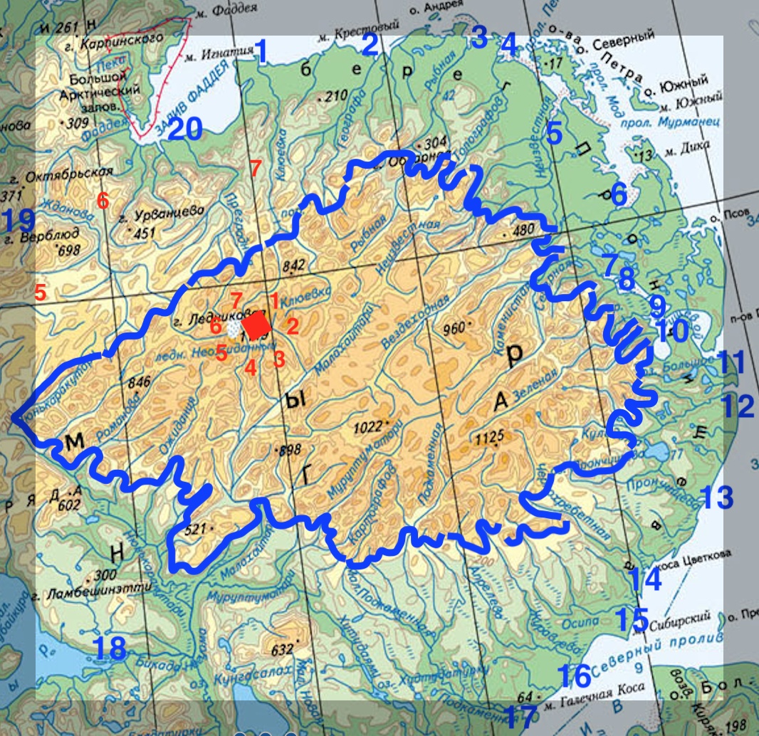
Fig 1: Mount Lednikovaya, seven interfluves and twenty rivers
The high, eastern part of the Byrranga range contains twenty water basins with a huge number of small rivers and streams (Fig. 1). Perhaps that fact served as the basis for the association that follows the verse 1.80.8 about rivers in the Rigveda:
Thousand (streams), do you chant as one. Twenty (rivers), encircle him with rhythm (सहस्रं साकम् अर्चत परि ष्टोभत विंशतिः RV 1.80.9).[24]
The concept of four main and twenty outlying rivers around the Navel of the Earth probably persisted in other cultures. (Compare the symbolic Navel of the World in the Church of the Holy Sepulchre in Jerusalem.)
In the Mahabharata the main point of the universe, the centre of the Meru massif, is Mount Mandara. The Rigveda singles out a rock, the Navel of the World, the place of Ida, where there is a certain plant from which soma is pressed. In considering hypothesis 2, I ask myself: Might two sacred Indian epics be telling about one and the same peak that has attributes of the main world mountain?
Secret Words
Specialists know that the texts of the Rigveda hymns are ambiguous in their meaning; their language is esoteric.
Speech hath been measured out in four divisions, the Brahmans who have understanding know them. Three kept in close concealment cause no motion; of speech, men speak only the fourth division (चत्वारि वाक् परिमिता पदानि तानि विदुर् ब्राह्मणा ये मनीषिणः गुहा त्रीणि निहिता नेङ्गयन्ति तुरीयं वाचो मनुष्या वदन्ति RV 1.164.45).[17]
Knowing of its track, he will speak [its names] like secrets – he, the inspired poet who strives on behalf of the later generation (विद्वान् पदस्य गुह्या न वोचद् युगाय विप्र उपराय शिक्षन् RV 7.87.4).[24]
Skilled in a thousand ways and means, the sages who protect the Sun (सहस्रणीथाः कवयो ये गोपायन्ति सूर्यम् RV 10.154. 5).[17]
In all probability, the lack of the words Meru and Mandara in the text of the Rigveda does not indicate the absence of those concepts among the Brahman milieu of the period when the Rigveda hymns were composed. As time passed, the taboo may have faded away, which could be the reason for the appearance of the name of the mountain and its peak in the Mahabharata. The root mand/mānd (मन्द्/मान्द्) is found in the Rigveda in different words.
The Sun, Dawns and Dusks
Mount Lednikovaya is situated at a latitude of 75.87°N. There the polar night lasts 98 nychthemera (24-hour periods), meaning the last ray of the Sun on 2 November and the first ray of the Sun on 9 February are separated by 99 nychthemera.[51] It was Tilak’s contention, later amended by Guseva, that this figure corresponds with the number of autumnal (शारद) ramparts or fortresses that Indra smashes and the number of Vritra’s rings (RV 1.165.15, 1.166.15, 1.167.11, 1.168.10). Indra has the constant epithets Śatakratu (शतक्रतु) – “one who performs 100 sacrifices” and Śatamanyu (शतमन्यु) – “one having hundred-fold wrath”, he who defeated 99 or 100 hard metal fortresses. Feasibly 99 or 100 is in fact the number of nychthemera in the polar night, when darkness to one degree or another enveloped the Earth (Tilak tells in chapter VIII of 100 sacrifices that are a sign of the maximum duration of the dark period). It is in this very place that it is possible to speak of a heavenly champion’s battle with an evil serpent or dragon that lasts 99 nights.
It is important to note that the day of the discovery of the demon Śambara (शम्बर), in Tilak’s interpretation of the phrase catvāriṃśyāṃ śarady (चत्वारिंश्यां शरद्य्) – on the fortieth (day) of the season of Śarada (शारद), points us to the day preceding the start of Indra’s struggle with the evil serpent.
He who discovered in the fortieth [day of] autumn Śambara as he dwelt among the mountains (यः शम्बरम् पर्वतेषु क्षियन्तं चत्वारिंश्यां शरद्य् अन्वविन्दत् RV 2.12.11).[17]
According to the Hindu calendar, the fortieth day of the season of Śarada, which is made up of the two lunar months of Ashvin and Kartika, falls on 1 November. Thus, the 40th day of Śarada is 10 Kartika. After the last ray of the Sun on the 11th day of Kartika (2 November) 99 nights will pass before the first ray of the Sun on the 20th day of Magha (9 February).[51]
In the text of the Rigveda we also find that Indra destroyed 99 fortresses of Śambara (नवतिं च नव-इन्द्रः पुरो व्य् ऐरच् छम्बरस्य RV 2.19.6). In other words, either Śambara is closely associated with Vritra, or Śambara is himself the evil serpent Vritra.
At 75.87°N in the middle of the polar night for 60 nychthemera not only are there no days, there is not even civil twilight.[51] Since the law of Ṛtá calls for the alternation of dark and light parts of the 24-hours,[18] this means that at that time (the season of Hemanta) there is no year.
This is how this location is described on the first day of the following season, Śiśira, in the well-known cosmogonic hymn of the Rigveda:
From Fervour kindled to its height Eternal Law and Truth were born: Thence was the Night produced, and thence the billowy flood of sea arose (ऋतं च सत्यं चाभीद्धात् तपसो ऽध्य् अजायत ततो रात्र्य् अजायत ततः समुद्रो अर्णवः RV 10.190.1).[17]
Commentary: throughout the season of Hemanta the heat of the Sun was invisibly present. As soon as the heat flared up underground on the first day of Śiśira (21 January), the fire Agni was born, bringing the first dawn light on Mandara, after which the night was born. For the whole of Hemanta there was no night, but only the great, boundless, extended, unorderly or un-instituted darkness. The alternation of day and night is reflected in the image of a troubled sea (the wave in this instance is the dawn).
From that same billowy flood of sea the Year was afterwards produced, Ordainer of the days and nights, Lord over all who close the eye [i.e. mortals] (समुद्राद् अर्णवाद् अधि संवत्सरो अजायत अहोरात्राणि विदधद् विश्वस्य मिषतो वशी RV 10.190.2).[17]
Commentary: the alternation of light and dark parts of the 24 hours is a necessary precondition for the existence of the year. For 60 nychthemera there was only darkness (from the last dusk to the first dawn at midday almost 61 times 24 hours pass). That may have found reflection in Latin culture, where, as mentioned above, until King Numa Pompilius there was an interval of 61 days in the calendar. When setting the date of the New Year, the Chinese calendar probably also required the renewal not only of the Moon, but also of the Sun. Traditionally, it excludes the first month after the winter solstice, the New Year coming at the time of the second new moon (after the 30th day of the Hindu lunar month Pausha – 20 January).
The Ordainer formed, as before, a pair of measures [of time, that is months] of the non-shining Sun, heaven and earth, the region between, and then sunlight (सूर्याचन्द्रमसौ धाता यथापूर्वम् अकल्पयत् दिवं च पृथिवीं चान्तरिक्षम् अथो RV 10.190.3).[11]
Commentary: underground (i.e., below the horizon) sunlight kindles the first dawn on Mandara – Mount Lednikovaya – on 21 January, the first day of the month of Magha. For the two months before that there are no dawns on the peak – the entire period passes in complete darkness with astronomical and nautical twilights at midday. It is precisely for those two months that the complete circuiting of bright stars can be observed at that geographical location.
Yojana
In the sacred texts, the dimensions of Meru and Mandara are given in thousands of yojanas (योजन). The minimum figure is 11,000 yojanas above and below the base of Mandara (МB 1.16.3).[36]
When discussing distances and measurements of length from the viewpoint of the compilers of the ancient legends, we need to clarify the meaning of certain concepts, such as “the height of a mountain below the ground”. Clearly ancient humans had no ability to measure subterranean distances using any sort of technology. By “the height of a mountain below the ground” they would have meant something other than the extent of the rock running into the depths of the Earth.
Hypothesis 4: The concept of “the height of a mountain below the ground” in the sources of the legends implies the distance travelled when moving along the south side of the mountains, or else the length of the southern half of the perimeter at the foot of the mountain. The concept of “the height of a mountain above the ground” in the sources of the legends implies either the distance travelled when moving from the southern limit of the mountain to its northern one or else the length of the northern half of the perimeter at the foot of the mountain.
Meanwhile just what the measurement of length that the Vedic bards called a yojana represented is vague. Various sources estimate the size of the yojana to be between 3.5 and 17 kilometres.[60] Even if we take the least value – 3.5 kilometres, the smallest distance linked to the sacred mountains, 11,000 yojanas, is equal to travelling around the globe, which defies common sense. That unequivocally indicates that the yojana meaning a day's journey was a later development, whilst at the time when the Mahabharata was written or the legends about Mandara were formed the concept of a yojana’s length had some other meaning. Logic suggests that for journeys on foot the unit should be such as to make calculating a distance easy. There are not many alternatives – either a single or a double pace.
Let us take another meaning of the word yojana – “harnessing” – and test the assumption that “harnessing” specifically refers to attaching a horse or ox to a cart, the joining of the two together, and, thus, “coupling”.
Hypothesis 5: The yojana as a unit of length is a double pace, the joining together of steps taken by the left and right feet. Accordingly, the distances in thousands of yojanas mentioned in the Mahabharata attests to another length for the yojana than a day’s march being used in the sources of the Vedic legends. The next unit – the vyāma or “arm span” (the distance between the fingertips of the outstretched arms) was, perhaps, once the equivalent of a double pace – योजन पदयोस्, पदयोजन or simply योजन.
A Sanskrit word closely related in both its root and sense – yuga (युग)[10] – means “pair, duet, bundle”,[47] and also denotes a measure of length (1 Yugais equal to 86 angulas (1.76*86=151.36 cm)[40]). "A pair of steps" was also the unit of length used to measure the distance of the Roman army's marches. The Roman mile was a mille (passus), milia passuum in the plural – a thousand double paces of about 1.48 metres (or 4’10”).[1]
The Iranian Achaemenid Empire also used the double pace called pank'a (1.48 metres) as a unit of length.[6] However, the Indo-Aryan vyāma (व्याम)[13] – the distance between the fingertips of outstretched arms – coincides in length with the double pace, the Iranian pank'a and the Roman passus.
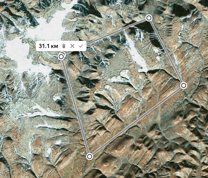
Fig 2: The foot of Mount Mandara-Lednikovaya
Let’s go around Mandara-Lednikovaya and measure the perimeter of its base. In the well-known episode of the extraction of amrita, this distance is important as the serpent Vasuki needs to be long enough to be wrapped around the mountain. A rough estimate of the length of the base perimeter of Lednikovaya would be 31 kilometres (Fig. 2).
And here is what is stated about the size of Mandara in the Adi Parva, the first book of the Mahabharata, Chapter 16, Verse 3:
It is 11,000 yojanas in height and is established to an equal number of thousands below the earth (एकादश सहस्राणि योजनानां समुच्छ्रितम् अधो भूमेः सहस्रेषु तावत्स्वेव प्रतिष्ठितम् МB 1.16.3).[36]
In Sanskrit “down” is equated with “south”, and “up” with “north”. In the Vedic language one mainly encounters the words उदञ्च् and न्यञ्च् which denote both concepts “north/up” and “south/down”.[40]
Let’s add the 11,000 yojanas below Mandara (on the south side of its base perimeter) and 11,000 yojanas above Mandara (on the north side of its base). Taking that figure of 22,000 and dividing it into the known perimeter of 31 kilometres, we arrive at the value of the Vedic yojana in the original account of a traveller who went around the mountain – roughly 1.41 metres. The Roman passus and Iranian pank’a measure 1.48 metres. The fairly small difference may be due to the rounding of the number of yojanas, the uneven hilly terrain, snow and/or the smaller stature of a northern traveller. On the other hand, the result obtained is out by a factor of (1.48 ‑ 1.41) ÷ 1.41 = 0.05 or 5%, representing a discrepancy only in the third significant digit. That is to say, the first two digits of the number calculated are correct, while there is an inaccuracy in the third. And that margin of error is no greater than the one in the starting data: 2 × 11,000 yojanas and 31 kilometres are also only accurate to the first two digits. So, the result has been obtained with a significant error in the third digit.
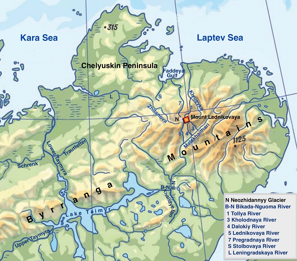
Fig 3: Map of the northern part of the Taimyr Peninsula
Now let’s try to describe the route to the summit of the Meru massif and northwards from there to the ocean. A convenient starting point for the traveler is Lake Taymyr, which extends 180 kilometres from east to west. After getting across the ice to its eastern edge, the next stage is to continue eastwards along the River Bikada-Nguoma, then to turn to the precise north after the mouth of the Kholidyetari. Advancing northwards along the Malakhaytari one can reach the base of Meru-Byrranga. It is possible to continue along the Malakhaytari, but there is a shorter route, going around the mountain clockwise, to the left, rather than the right.
Perhaps an account of this very route (bypass Mount Meru, then to the northern edge via the summit) was given in the forerunner to the legend in Canto 5 of the Śrimad Bhagavatam (Bhagavata Purana). It states that Meru (Sumeru) has a height of one lakh [100,000] yojanas, with its root lying under the earth's surface to a depth of 16,000 yojanas, and thus the mountain is only 84,000 yojanas high above the earth's surface (यो वायं द्वीप: कुवलयकमलकोशाभ्यन्तरकोशो नियुतयोजन विशाल: समवर्तुलो यथा पुष्करपत्रम् ॥ ५ ॥, कुवलयकमलस्य मूर्धनि द्वात्रिंशत् सहस्रयोजनविततो मूले षोडशसहस्रं तावतान्तर्भूम्यां प्रविष्ट: ॥ ७ ॥ ŚB 5.16.5, 5.16.7).[50]
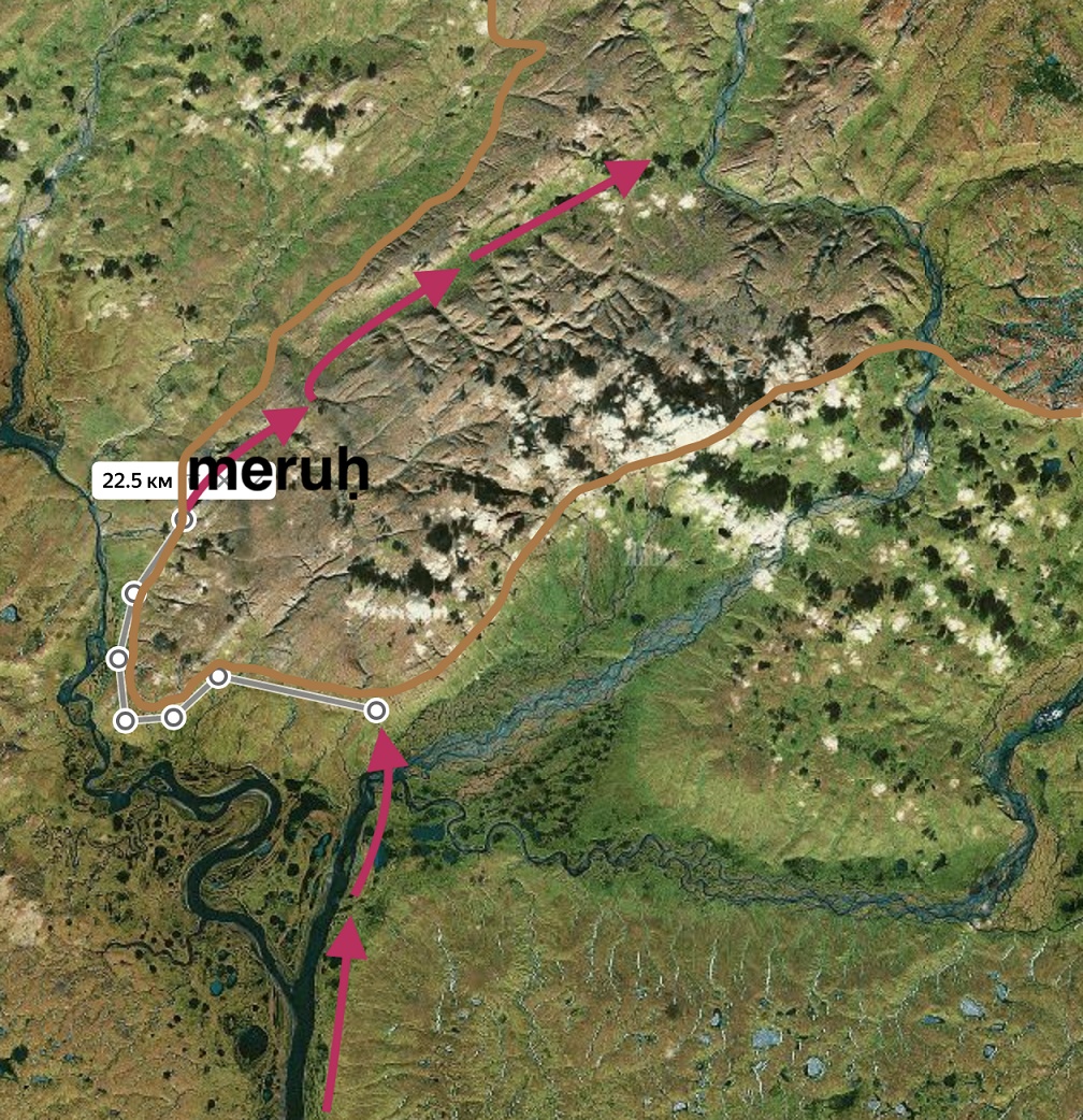
Fig 4: The initial part of the route through Meru

Fig 5: The main part of the route through Meru
The short route entails 16,000 double paces “below the mountain”, meaning “at the foot of the mountain” or “on the south side of the mountain”, (16×1.41=22.56 km, Fig 4) and 84,000 double paces “upwards”, “from the foot of the mountain to its topmost [northernmost] point”, (84×1.41=118.44 km, Fig 5).
An interesting text about Meru is included in the Vishnu Purana:
Its height is eighty-four thousand yojanas; and its depth below the surface of the earth is sixteen thousand. 32 [thousands] in the largest part spread out at the base [at] 16000 [from the top] space (=spread) of it everywhere (=in all directions)(चतुरशीतिसाहस्रो योजनैर् अस्य चोच्छ्रयः प्रविष्टः षोडशाधस्ताद् द्वात्रिंशन् मूर्ध्नि विस्तृतः मूले षोडशसाहस्रो विस्तारस् तस्य सर्वतः 2.2.8 and 2.2.9).[61]
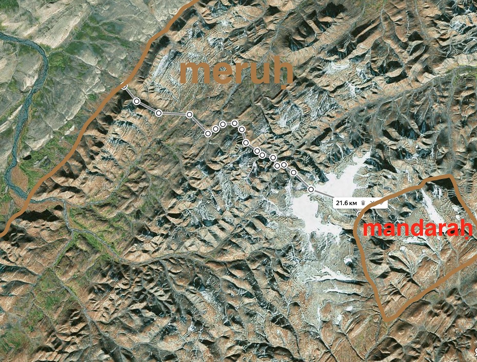
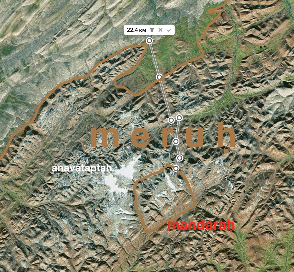
Fig 6-7: Routes from Mandara to the northern edge of Meru.
The 16,000 yojanas down below has already been discussed. It is more difficult to make sense of the other measurements. It should be noted that from the northern corners of Mandara to the northern edge of Meru there are roughly 16,000 yojanas, while from the southern corners of Mandara Meru extends much farther in a southerly direction (Figs. 5, 6 and 7).
Summarizing this section, it should be noted that 22 (11+11) thousand yojanas, as well as the other distances (16, 84 and 100 thousand), are in proportion to their prototypes (in meters) at the location in question with the same coefficient of 1.41. That makes it possible to declare a complete match between the mountains described in the ancient texts and actual geographical objects in the Byrranga range.
Dvipas
The meaning of the Sanskrit word dvipa (द्वीप) is "island", "peninsula", or "continent".[62]
Hypothesis 6: In Vedic times “dvipa” referred to a body of land surrounded by water on two sides, including an interfluve.
Indian religions present two different pictures of the territories surrounding Meru. Some assert that seven dvipas adjoin the summit of Meru (the Hindu view); others state that there are four dvipas (the Buddhist view) located around Meru. It is interesting that Jambu-dvīpa (जम्बुद्वीप) is included among the dvipas in both the first and second concepts. What is the explanation for the discrepancy between these two concepts?
Let us look what is written in the sacred texts. In puranas it is stated that there are seven dvipas around Meru.
It seems that the description of Meru in later Indian sources sometimes follows the account of the summit ofMeru from early sources.
The Śrimad Bhagavatam informs us that the rolling wheels of Maharaja Priyavrata’s chariot created seven ditches, in which the seven oceans came into existence. Because of these seven oceans, [the land] is divided into seven islands (तत्रापि प्रियव्रतरथचरणपरिखातै: सप्तभि: सप्त सिन्धव उपक्लृप्ता यत एतस्या: सप्तद्वीपविशेषविकल्पस्त्वया ŚB 5.16.2).[50] The Shiva Purana (1.15) tells of sevensacred Gangas.[62]
It would seem that in the source of the sacred legends seven dvipas were located not around Meru, but around the summit of Meru – that is, Mandara (Fig. 1). A mountain peak Mandara plus seven mountainous dvipas – that situation could well be reflected in the Rigveda, which speaks of eight humps (summits) of the earth (अष्टौ ककुभः पृथिव्यास् RV 1.35.8).[24]
The Indian epics state that the heavenly Ganga comes down from above onto the summit of Meru (ŚB 5.17). It begins to flow across the Earth in all four directions. If we examine the rivers around Mount Lednikovaya, we see that this is indeed the case, provided one takes “river” to mean the basin of a river with all its tributaries, including streams. Altogether around Lednikovaya there are seven watercourses and thus seven interfluvial landmasses – dvipas. We can also observe four channels of the heavenly Ganga – four rivers flowing in different directions away from the summit (Fig. 3). Flowing westwards from Lednikovaya is the western course of the Ganga – the River Zhdanova (1 channel). To the north of the mountain, the Ganga begins to flow along its northern course – the River Pregradnaya (1 channel). Running off eastwards is the eastern course of the Ganga – the River Kluyevka and its tributary the Tollya, (2 channels) – which then turns towards the north. Rushing southwards is the southern course of the Ganga – three tributaries of the River Malakhaytari (3 channels – the Kholodnaya, Dalyokiy and Lednikovaya). It seems to me that the four dvipas mentioned in Buddhist texts are a reflection of the four bodies of land between the courses of the heavenly river. The seven dvipas (in Hindu texts) are the small mountainous interfluves, while the four dvipas are the larger highland-and-plain interfluves. So both groups are correct – those who believe that there are seven dvipas around the summit of Meru, i.e., Mandara, and those who received the lore that there are only four dvipas around Meru.
This is his (Indra's) most conspicuous deed, the dearest wonder of the wondrous one, that he made the four nearer (Heavenly) rivers with their honeyed floods swell in their eddying (तद् उ प्रयक्षतमम् अस्य कर्म दस्मस्य चारुतमम् अस्ति दंसः उपह्वरे यद् उपरा अपिन्वन् मध्वर्णसो नद्यश् चतस्रः RV 1.62.6).[24]
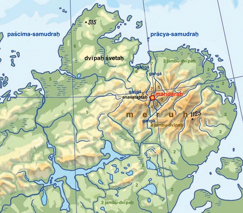
Fig 8: Map of the sites of the Ancient Indian Sacred Epics
Fig. 8 shows that the first, third and fourth dvipas are mountainous. They are situated only in the highlands around Mandara, the summit of Meru, and do not extend into the plain. The fifth, sixth and seventh dvipas are simultaneously areas of high and low land. They are situated both around Mandara-Lednikovaya and around Meru – the Byrranga range.
The second dvipa, which also contains both highland and lowland parts, starts off eastwards from Lednikovaya. Then it extends southwards. In Fig. 8, the number 2s mark the watershed along which one can walk from Mandara-Lednikovaya to places of human habitation without having to cross a river. The following are the arguments which allow us to classify this largest territory among the four dvipas around Meru (as stated in the Markandeya-purana Canto 54)[37] or the seven dvipas around Mandara as the most famous dvipa of Asia – Jambu-dvipa.[56]
This interfluve is the only one of all the dvipas where people do live (if we consider people to mean the inhabitants of the middle and southern latitudes). It is the continental dvipa.[64] One can reach almost anywhere in Eurasia while remaining within this dvipa, without having to cross a watery barrier. In the Buddhist cosmogonic concept, this is the only dvipa on which people live.[55] It is located to the south of Meru.[31] Its sea coastline curves smoothly, forming a semicircle.[28] It starts from Mandara, with the southern course of the Heavenly Ganga on the right side at the beginning of the route; along this watershed divide one can reach India. In the Jainist cosmogonic concept of the inhabited dvipas, there are three, people live on Jambu-dvipa and one and a half territories of two more dvipas.[52] This may make sense if we consider part of the Jambu-dvipa as the interfluve of the Lower Taymyra and Khatanga river basins, and the remaining two dvipas as other interfluves of the North Siberian Lowland inhabited by ancient reindeer hunters. The two habitable oceans mentioned by the Jains may be the vast basins of Lower Taymyra and Khatanga-Popigai.
The remaining three upland-lowland dvipas of Meru (fifth, sixth and seventh) end at rivers, lakes or the ocean, and are not inhabited. It is stated in the Bhagavata Purana:
Amidst these divisions, or varṣas, is the varṣa named Ilāvṛta, which is situated in the middle of the whorl of the lotus. Within Ilāvṛta-varṣa is Sumeru [Meru] mountain, which is made of gold. Sumeru Mountain is like the pericarp of the lotus…. The mountain's height is the same as the width of Jambūdvīpa (एषां मध्ये इलावृतं नामाभ्यन्तरवर्षं यस्य नाभ्यामवस्थित: सर्वत: सौवर्ण: कुलगिरिराजो मेरुर्द्वीपायामसमुन्नाह: कर्णिकाभूत ŚB 5.16.7).[50]
If Ilā is associated with the Heavenly Ganga, then perhaps Ilāvrita (Ilāvṛta) is the territory associated with the basins of the four Gangas. It is notable that the height of Meru (the distance between its southern and northern limits) is roughly equal to the width of Jambu-dvipa. In Fig. 8, the Meru mountain range can be identified by the shades of terracotta colour; the number 2s mark the territory of Jambu-dvipa.
Shveta-dvipa
The Indian legend of the sage-divinity Narada (Mahabharata 12.322) informs us of one important detail that could scarcely have been invented – the existence on the coast, or close to it, of a peninsula or island. The reference is to the island (or promontory) Shveta-dvipa located at a distance of 32,000 yojanas to the north of the Meru mountains. This land lies to the north-west of Mandara.
Endued with high Yoga-puissance, Narada suddenly soared into the firmament and reached the summit of the mountains of Meru [i.e., Mandara]. Proceeding to a retired spot on that summit, the great ascetic took rest for a short while. He then cast his eyes towards the north western direction and beheld an exceedingly wonderful sight. Towards the north, in the Milk Ocean, there is a large island named the White Island. The learned say that its distance from the mountains of Meru is greater than two and thirty thousand Yojanas [(खमुत्पपातोत्तमवेगयुक्तस्ततोऽधिमेरौ सहसा निलिल्ये ॥ तत्रावतस्थे च मुनिर्मुहूर्तमेकान्तमासाद्य गिरेः स शृङ्गे । आलोकयन्नुत्तरपश्चिमेन ददर्श चात्यद्भुतरूपयुक्तम् ॥ क्षीरोदधेरुत्तरतो हि द्वीपः श्वेतः स नाम्ना प्रथितो विशालः । मेरोः सहस्रैः स हि योजनानां द्वात्रिंशतोर्ध्वं कविभिर्निरुक्तः MB 12.322).[50]
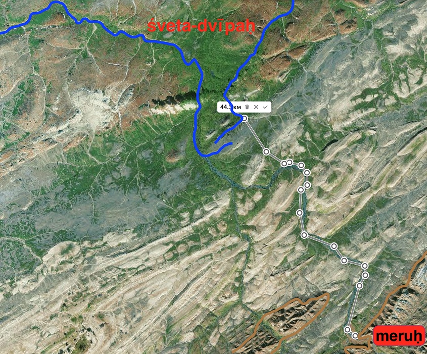
Fig. 9: Possible route from Meru to Shveta-dvipa
Let us head off with the ancient hunters to the north of Eurasia. We pass over the Meru range from south to north, and continue along the bank of the western channel of the Heavenly Ganga (the River Zhdanova, Fig. 9). Covering 32,000 double paces, we find ourselves at the source of the River Stolbovaya, which no longer flows westwards, towards the Kara (Western) Sea, but northwards, towards the Faddey Bay of the Laptev (Eastern) Sea. To the north of those two rivers lies the Chelyuskin peninsula (Fig. 3).
Shveta-dvipa is situated to the north of the sixth dvipa, across a very narrow isthmus. It forms a part of that dvipa and sticks out into the ocean. If we are to believe the legend that people live only on the second dvipa (Jambu-dvipa), then it means some other beings lived on Shveta-dvipa, and not humans.
The denizens of that realm have no senses. They live without taking food of any kind. Their eyes are winkless. They always emit excellent perfumes. Their complexions are white. They are cleansed from every sin. They blast the eyes of those sinners that look at them. Their bones and bodies are as hard as thunder. They regard honour and dishonour in the same light. They all look as if they are of celestial origin. Besides, all of them are endued, with auspicious marks and great strength. Their heads seem to be like umbrellas. Their voices are deep like that of the clouds. Each of them has four Mushkas. The soles of their feet are marked by hundreds of lines (अतीन्द्रियाश्चानशनाश्च तत्र निष्पन्दहीनाः सुसुगन्धिनश्च श्वेताः पुमांसो गतसर्वपापाश्चक्षुर्मुषः पापकृतां नराणाम् वज्रास्थिकायाः सममानोन्माना दिव्यान्वयरूपाः शुभसारोपेताः छत्राकृतिशीर्षा मेघौघनिनादाः सत्पुष्करचतुष्का राजीवशतपादा MB 12.322).[50]
The traveller sees nothing edible around them? Why do they seem indifferent? Do they make people look away? Do their voices resemble peals of thunder? Are their bodies white like clouds? Are their heads flat? The word Mushka (मुष), as ordinarily understood, implies the scrotum or testes. The 17th-century commentator Nilakantha supposes that it may stand for the shoulder-knot. He believed the phrase to imply that the inhabitants of this island each had four arms. The subsequent description of their soles, possibly marked with papillary lines, suggests that we are talking about the pads of the toes on an animal's paws.
What were the white beings that inhabited those regions? Perhaps they were polar bears,[60] which still live along the coast of the Chelyuskin Peninsula.
Rivers
The Rigveda (1.35.8, 1.32.12, 2.12.3) describes seven (सप्त) great (महिन) great rivers (सिन्धु). It is believed that their names are given in hymn 10.75.5. Could the seven small rivers around Mandara-Lednikovaya be the prefigurations of the seven mighty rivers of the Veda, the Sapta-sindhava?
It does not seem to me that they can. First of all, the rivers around Mandara are of no notable size, which prevents them being called “great”. Secondly, as some hymns of the Rigveda state, an important attribute of a great river is that it flows into the sea.
Let the drops pass within thee as the [great] rivers flow into the sea (आ त्वा विशन्त्व् इन्दवः समुद्रम् इव सिन्धवः RV 8.92.22).[17, 8.81.22]
As [great] rivers reach the sea, so, strong with praises, our holy songs reach him the Comprehensive (षऌ अस्तभ्ना विष्टिरः पञ्च संदृशः परि परो अभवः सास्य् उक्थ्यः RV 6.36.3).[17]
In the North Siberian Lowland, seven major river basins can be identified – those of the rivers Lena, Olonyok, Anabar and Uele, Khatanga and Popigay, Lower Taymyra, Pyasina, and, finally, the Yenisei. Thus there are six bodies of land between the rivers. Let us note that in the hymn about Indra six broad expanses are mentioned:
The six directions hast thou fixed, a five-fold view: thy victories reached afar. Worthy of lauds art thou (समुद्रं न सिन्धव उक्थशुष्माः उरुव्यचसं गिर आ विशन्तिRV 2.13.10).[17]
I suggest that the reference is to the six areas between the seven rivers, while the five-fold view is in the four primary compass directions and looking upwards.
It seems probable that the (twice) three adjoining desert regions (त्री धन्व योजना – two times three, as grammatically trī is in the dual form) mentioned in RV 1.35.8 are also the six interfluves.
The rivers flow into the Arctic Ocean from the south, which is why
By his greatness he made a sindhu to flow northward (सोदञ्चं सिन्धुम् अरिणान् महित्वा RV 2.15.6).[24]
Proceeding from the idea that the basin of the Lower Taymyra (singly or with three other basins) is the Ganga in the hymn RV 10.75.5, we can observe that among all the great rivers the Ganga has primary significance due to its proximity to the location of the gods (the southern stream of the Heavenly Ganga adjacent to Mandara-Lednikovaya enters the Lower Taymyra basin). That is why it could be addressed simply as “Sindhu” – “the great river”.
Her (Sindhu's) sound takes its place in heaven, above the earth (दिवि स्वनो यतते भूम्योपर्य् अनन्तं शुष्मम् उद् इयर्ति भानुना RV 10.75.3).[24]
The hydrographic system of the Ganga/Lower Taymyra, of which the southern course of the Heavenly Ganga is a part, can be divided into two sections – the basins of the Bikada-Nguoma, the Trautfetter and other tributaries located to the east (right) and the basins of the Upper Taymyra, Schrenk and other rivers on the west (left). Let us look at the text of hymn 10.75.4 from that viewpoint:
Like mothers crying for their sons, [the other rivers] hasten towards you, Sindhu [the Great River Ganga], like cows with their milk; you lead your two wings [eastern and western, or right and left] like a king going to battle when you march in the van of the streams that are descending [with you] (अभि त्वा सिन्धो शिशुम् इन् न मातरो वाश्रा अर्षन्ति पयसेव धेनवः राजेव युध्वा नयसि त्वम् इत् सिचौ यद् आसाम् अग्रम् प्रवताम् इनक्षसि 10.75.4).[17]
Identifying the rivers mentioned in hymn 10.75.6 with actual geographical objects is no easy matter.
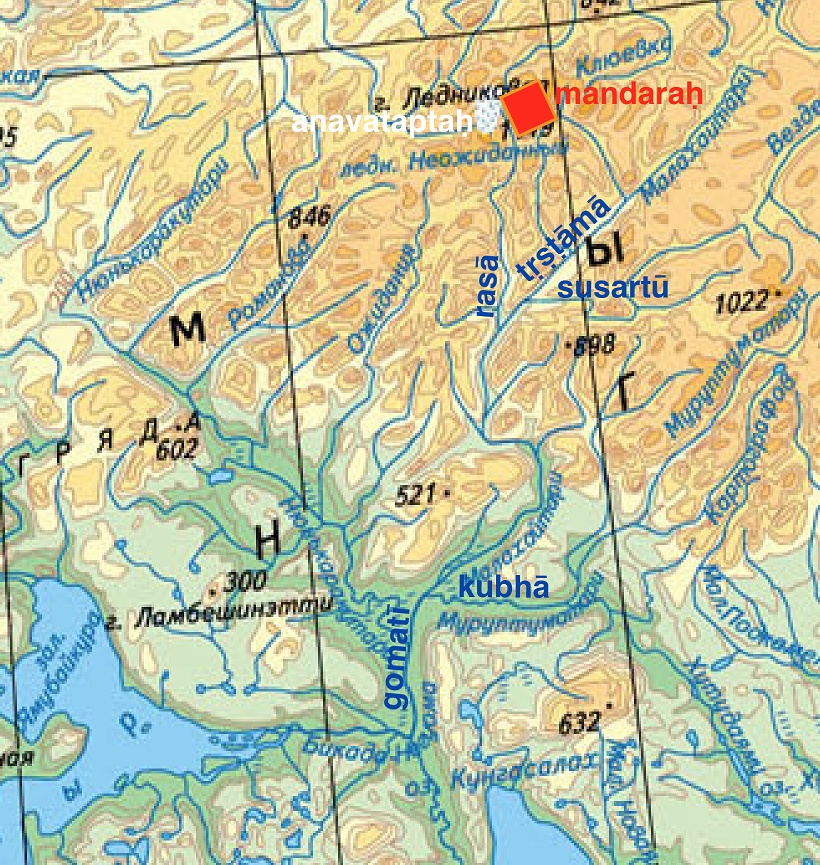
Fig. 10: Map of the upper part of the Great River Ganga with variant names of its tributaries
To travel first joined with the Tr̥ṣṭāmā, [then] with the Susartū, [and also with] that same white Rasā, you, o Sindhu, [come] with the Kubhā to the Gomatī, with the Mehatnū to the Krumu, on the same chariot [with all these], with which you go speeding (तृष्टामया प्रथमं यातवे सजूः सुसर्त्वा रसया श्वेत्या त्या त्वं सिन्धो कुभया गोमतीं क्रुमुम् मेहत्न्वा सरथं याभिर् ईयसे 10.75.6).[24]
It might be suggested that there are some grounds for identifying the Rasa (a white river) with the River Lednikovaya (Fig. 10) on account of the white colour of the Neozhidanny glacier from which it flows (the modern name Lednikovaya comes from lednik, Russian for “glacier”). There are also reasons to compare the Gomati (a river rich with cattle) with the Bikada-Nguoma River or part of it. It can be assumed with a high degree of probability that in the 3rd millennium BCE, the plain adjacent to the river served as a summer gathering place for the eastern migration flow of Taymyr reindeer. In 2020, that spot was located slightly further south, in the lower reaches of the River Kholidyetari (Fig. 3).[53]
The search for the territory across which the rivers listed in hymn 10.75.6 flow might be a topic for future research.
Lakes
Buddhist texts – the Lalitavistara (ललितविस्तर 332.12), Divyāvadāna (दिव्यावदान 150.23, 152.23, 153.4, 344.13, 399.14), Śikṣāsamuccaya (शिक्षासमुच्चय 247.12), Daśabhūmikasūtra (दशभूमिकसूत्र 95.17), and Karmavibhaṅga (कर्मविभङ्ग 62.1) – tell us that on the northern edge of Jambu-dvipa, in the Snowy Mountains (हिमवत्), there is Lake Anavatapta (अनवतप्त), a name which means “free from heat”. [62] Four rivers flow out of this lake.[39] Based on what was said above, the Snowy Mountains are Meru-Byrranga, and the northern boundary of Jambu-dvipa may be located near Mandara. However, there are no lakes in the Mandara-Lednikovaya area. Moreover, from a hydrological point of view, a lake from which four rivers flow cannot form.
All the lakes on the Taymyr peninsula lose their covering of ice in summer, so they do warm up. However, there is one place in the Byrranga range that has an icy crust even in July. That is the Neozhidanny glacier that lies at the western foot of Mount Lednikovaya. The mountain most probably got its present name from the glacier (lednik). The lake mentioned in Buddhist treatises as Anavatapta may not be a body of water, but a mass of ice (anavataptaḥ in the illustrations) lying at the foot of the summit of Meru, Mount Mandara. Today, waters from this glacier feed the rivers of all four basins around Mount Lednikovaya (the Tollya, Lednikovaya, Zhdanova and Pregradnaya rivers, Figs. 1 and 3).
Etymology
Today the Far North of Eurasia is inhabited mainly by peoples who speak languages belonging to the Samoyedic group. If the population of the Taymyr in the 3rd millennium BCE (the Bel’kachi archaeological culture)[27] spoke Proto-Samoyedic/Proto-Uralic, individual words or place-names may have passed over into the Vedic language. The musings listed below are in the nature of suggestions and require expert assessment.
1. Mandala (मण्डल). The etymology of this word can indeed be traced through Samoyedic languages. The root mandal/y means “bundle”, “circle” or “ball”.[54] [29] It can be assumed that this word was borrowed into the Vedic language.
2. Ganga (गङ्गा). The velar nasal sound in Samoyedic languages represented in phonetic transcription as ŋ and commonly written as "ng" may have changed to a plain g in the first syllable when borrowed into Vedic.
The first syllable nga may have a root connected with one meaning “distant” in Nenets[54] or the word for “sky” in Enets.[49] The second syllable occurs in the names of rivers in the Far North (e.g. the Khatanga, a river situated to the south of the Lower Taymyra basin).
3. Gungu/Ganga. Part of the southern course of the Heavenly Ganga, the Bikada-Nguoma river, has Nganasan roots: ngu, meaning “god” or “heaven”, and ma, meaning “house” or “tent”. [29] The word bikada means “a big river”. [29] Possible translations for the name Bikada-Nguoma would be “Big River of the Heavenly House” or “Big River of the House of the Gods”, which fits with the Ganga, the sources of which are on Meru, the dwelling place of the gods:
I invoke her who is Guṅgū [a deity, possibly Proto-Samoyedic], who is Sinīvālī, who is Rākā, who is Sarasvatī; (I invoke) Indrāṇī for protection, Varuṇānī for welfare (या गुङ्गूर् या सिनीवाली या राका या सरस्वती इन्द्राणीम् अह्व ऊतये वरुणानीं स्वस्तये RV 2.32.8).[24]
4. Yamuna (यमुना). In various Samoyedic languages yamu (yam/dyama)[54], [29] means “much water”, “sea”, “great river”.
5. Arimaspians[60] (Latin Arimaspi; Ancient Greek Ἀριμασπός, Ἀριμασποί). Human habitation in the Far North in the 1st millennium BCE would have required sources of fuel (tracts of woodland) close by. The population of the North Siberian Lowland might be called “inhabitants of forest islands”. It is possible that the Proto-Turkic-speaking tribes living to the east of the Scythians passed on to them stories about “forest islanders” dwelling to the north of them (in the present-day North Siberian Turkic language Dolgan the toponym Ary-Mas means “forest island”).[60] The Scythians, in turn, transmitted information to the Ancient Greeks about who lived to the south of the Riphean Mountains.
Conclusions
The present paper touches upon several interconnected topics, examining them only superficially due to the limited space. Each of the areas mentioned requires more detailed and in-depth study. I consider the points listed below to be preliminary conclusions with the prospect of further refinement.
On the basis of a comparison of the natural features described in ancient Indian epics with real geographical objects, I have identified the following correspondences:
1. The world mountain Meru is probably the eastern massif of the Byrranga, or else the entire Byrranga range.
2. The summit of Mount Meru – Mandara in the Mahabharata, the Navel (Summit) of the Earth (World) in the Rigveda – is the mountain now called Lednikovaya, located at 75°52′40″N, 107°48′33″E. Mandara-Lednikovaya is included within the Jambu-dvipa in the Buddhist concept, but likely is not part of any of the seven dvipas in the Hindu concept.
3. The southern course of the Heavenly Ganga is the basin of the Lower Taymyra river. The Ganges or Ganga of the Indian subcontinent was given the name of the river in the Far North. That transfer was made by the Aryans or their descendants.
4. The eastern course of the Heavenly Ganga is the basin of the River Klyuyevka.
5. The western course of the Heavenly Ganga is the basin of the River Zhdanova-Leningradskaya.
6. The northern course of the Heavenly Ganga is the basin of the River Pregradnaya.
7. Lake Anavatapta is the Taymyr’s only massive glacier – Neozhidanny.
8. Shambara’s 99 fortresses of darkness are connected with the length of the period between the last and first rays of sunlight on Mandara-Lednikovaya – between the 11th day of Kartika (2 November) and the 20th day of Magha (9 February).
9. The two months of great darkness (sūrya-acandra-masau) when the Sun does not shine even from below the horizon are connected with the length of the period between the last and first twilights on Mandara-Lednikovaya – from the 30th day of Kartika (21 November) to the 1st day of Magha (21 January).
10. The Vedic Seven Rivers (Sapta Sindhu) are probably connected to the territory of the river basins of the Lena, Olonyok, Anabar and Uele, Khatanga and Popigay, Lower Taymyra, Pyasina, and Yenisei.
11. In the early Vedic period the word yojana referred to the length of a double pace.
12. Besides the established ones, the meanings of the word dvipa can be considered to include “interfluve” or “land between bodies of water”.
13. Seven dvipas are situated between the rivers Klyuyevka, Kholodnaya, Dalyoky, Lednikovaya, Zhdanova, Pregradnaya, and Tollya.
14. The four dvipas are the interfluves between the Klyuyevka, Bikada-Nguoma (Lower Taymyra), Zhdanova (Leningradskaya), and Pregradnaya. The centre of four dvipas is the Glacier Anavatapta- Neozhidanny).
15. Shveta-dvipa is the Chelyuskin peninsula. Besides the coastlines on the Kara and Laptev Seas, the boundary of Shveta-dvipa runs along the river Zhdanova (Leningradskaya) and, probably, the Stolbovaya.
Further study
In my future work I propose to:
– find mentions of the prototypes of geographical features to the south of Meru/Byrranga in ancient Indian texts
– examine Vedic descriptions of the world tree and suggest nature-based explanations of it
– analyse in detail the Sun’s cycle at its throne (Mandara)
– find correspondences between the geographical objects described in the Avesta and real-life prototypes.
I call upon specialists to carry out their own investigation into certain topics that I consider important:
– the linguistic influence of Proto-Uralic on Vedic Sanskrit
– the connection between Shveta-dvipa and Hyperborea, the island of Thule and Shambhala
– the connection between the shape of Mandara and the symbolic depiction of Golgotha in Orthodox Christianity, the depiction of the Masonic Eye of Providence, and the shape of religious buildings in cultures worldwide.
– the question of whether Meru is the whole of the Byrranga mountain range, or only its highest, eastern, part
– the connection between the location of paradise, cosmogonic centre of the universe and a world mountain and its peak in cultures around the globe.
Gratitude
I would like to thank the following for their assistance in writing this paper:
Leonid Samuilovich Butman for translations from Sanskrit and valuable comments;
Tatyana Gringlaz for editing and assistance in finding sources;
Paul Williams for translation from Russian into English and assistance in finding sources.
Conflicts of Interest
The author declares no conflict of interest.
References
- A new classical dictionary of Greek and Roman biography, mythology and geography, Smith, W. and Anthon, Ch. Table IV – Roman Measures of Length. New York, 1860.
- Ancient History Bulletin. volume 3, 2017, p. 328.
- Aristotle. Meteorologica. Webster, E.W. Oxford, Clarendon Press, 1923. Book 1, Part 13.
- Avesta. Vendidad. Sacred Books of the East, Darmesteter, J. fargard 2.40. American Edition, 1898.
- Avesta. Yasht 10.88 https://www.avesta.org/ka/yt10sbe.htm
- Belobrov, V. A. Metrology of the Land of the Ayrans. p. 13. https://www.academia.edu/
- Bondzhev, A. 2023. Ancient Sources about Hyperborea. Sofia, New Bulgarian University, Department of History, 2023..
- Bongard-Levin, G.M., Grantovsky, E.A. Ot Skifii do Indii. Drevnie arii: mify i istoriia [From Scythia to India, The Ancient Aryans: Myths and History]. Moscow, 1983. pp. 24-31, 51-52.
- Brogan, O. 1942. Anicent history to A.D. 500. Annual Bulletin of Historical Literature. III 30, 1942, pp. 11-19.
- Butman, L. S. Proof of krichenbauer’s hypothesis: Ushas as the first dawn of the New Year - the key to solving the rigveda’s narrative puzzle. International Journal of Sanskrit Research 2026; 12(1), pp. 497, 501.
- Butman, L. S. The revision and clarification of the use words denoting the terms: ‘Moon’, ‘Month’, ‘Sun’, ‘Earth’ and the Verb ‘To be born’ in Vedic Sanskrit. International Journal of Sanskrit Research 2025; 11(2): pp. 18-27.
- Byrranga topographic map https://maps47.narod.ru/indexs4748.html
- Danino, M. New Insights into Harappan Town-Planning, Proportions and Units, with Special Reference to Dholavira. Man and Environment, vol. XXXIII. 1 2008, pp. 66-79 p. 13.
- Geldner K. F., Der Rig-Veda aus dem Sanskrit ins Deutsche übersetzt und mit einem laufenden Kommentar versehen, Cambridge (Mass.), 1951-1957.
- Golding A. The Worke of Pomponius Mela the Cosmographer concerning the Situation of the World, London, 1585.
- Greater Bundahishn, Anklesaria, B. T., 1956., chapter 10.
- Griffith R. T. H. The hymns of the Rigveda, translated with a popular commentary. Benares, 1889-1891.
- Gringlaz A., Butman L. Regarding the search for the territory described in the hymns of the Rigveda. International Journal of Sanskrit Research. 2025. Vol. 11, Issue 4, Part C, pp. 152, 153, 160.
- Gringlaz, A. Youtube-channel Zemlya mnogorogikh korov (in Russian, with English subtitles). Episode 15 https://youtu.be/XNo-ZOXyWuI?si=WuIfxfKKVlsXCNVy and other releases.
- Gringlaz A. Personal website https://gringlaz.com/
- Guseva, N. R. 2010. Russkiy Sever-prarodina indoslavov [The Russian North-ancestral home of the Indo-Slavs]. chapter: Temneye vsego pered rassvetom. Moscow Veche, 2010.
- Hildebrandt, A. Vedische Mythologie. Vol. 2 1899, M. & H. Marcus 1927 & 1929, Breslau, 1927 p. 26.
- Houtsma, M. Th. E.J. Brill's First Encyclopaedia of Islam, 1913-1936. 1987. p. 616.
- Jamison S. W., Brereton J. P. The Rigveda.The Earliest Religious Poetry of India. The University of Texas South Asia Institute and Oxford University Press, 2014.
- Justinus. Epitome of the Philippic History of Pompeius Trogus. Watson, J. S., London : 1853. Book 2, Chapters 1-3.
- Khalilova, T. Sh. Predstavleniya o Ripeyskikh gorakh v drevnegrecheskoy i indopersidskoy literature. [Representations of the Riphean Mountains in Ancient Greek and Indo-Persian Literature]. Vestnik Mezhdunarodnoy akademii nauk. 2020.
- Khlobystin, L. P Taymyr: The Archaeology of Northernmost Eurasia. W. W. Fitzhugh and V. V. Pitul'ko, 2005.
- Knudsen, T. L. Three Purāṇic Statements on the Shape of the Earth. https://www.wisdomlib.org/
- Kosterkina, N. T. Slovar’ nganasansko-russkii i russko-nganasanskii [Nganasan-Russian and Russian-Nganasan Dictionary]. St Petersburg, 2001. pp. 23, 93, 94, 95, 138.
- Krichenbauer, A. Theogonie und Astronomie. Vienna, Carl Konegen, 1881. p. 348.
- Ksitigarbha Bodhisattva Purvapranidhana Sutra Chapter 4. https://www.wisdomlib.org/buddhism/book/the-sutra-of-the-past-vows-of-earth-store-bodhisattva/d/doc7741.html
- Kuiper, F.B.J. The ancient Aryan verbal contest. Indo-Iranian Journal, 1960 vol.4. pp. 217-281.
- Livius, L. The History of Rome. translator D. Spillan. London, 1853, I, 19.
- Ludwig, A. Der Rigveda. Vienna F. Tempsky, 1876. p. 11.
- Macro- and micro-research in prediction and the significance of measurement systems. Istorical evolution of India an assessment of ideals of the Aryan civilization. Singh R. S., Tiwari S. Kr., Verma B. Kr. Indian institute of technology.
- Mahabharata. Sanskrit texts, Ganguli translation, Dutt translation https://www.mahabharata.shreevatsa.net
- Markandeya-purana Canto 54 https://www.wisdomlib.org/hinduism/book/the-markandeya-purana/d/doc117101.html
- Melae, P. Chorographia libri 3 by Parthey G. Henrico Kiepert, 1867 chapter 5.
- Moerman, M., Xuanzang à Paris: The European Reception of the Japanese Buddhist World Map. Columbia University, 2021.
- Monier-Williams, A Sanskrit-English Dictionary (enlarged edition). Sir Monier. 1899., pp. 184, 1298, 1304, 1305.
- Moonrise website, https://www.timeanddate.com/moon/
- Paleoklimat polyarnykh oblastey Zemli v golotsene [Paleoclimate of the Polar Regions of the Earth in the Holocene]. Bolshiyanov D.Yu., Verkulich S.R.. (eds). St. Petersburg., 2018. pp. 42, 181.
- Pliny's Natural History. Bostock J., Riley H. T. London, 1855. Book 4. Chapters 26, 88.
- Regional'nye osobennosti izmeneniya prirody Tajmyra v golotsene (Regional features of changes in the nature of Taimyr in the Holocene). Belorusova Z. M., Lovelius N. V., Ukraintseva V. V. Botanicheskij jurnal. 5 1987 v.72, pp. 610-618.
- Roman republican calendar. Encyclopaedia Britannica. 2025, Britannica Editors. https://www.britannica.com/science/Roman-republican-calendar.
- Romer, F. E., Pomponius Mela's Description of the World. Ann Arbor., University of Michigan Press, 1998.
- Shabda-Sagara Sanskrit-English Dictionary https://www.sanskrit-lexicon.uni-koeln.de/scans/SHSScan/2020/web/
- Sophocles. The Oedipus at Colonus of Sophocles. Sir Richard Jebb, R. Cambridge, Cambridge University Press. 1889. pp. Verses 1240–1250.
- Sorokina I.P., Bolina D.S. Slovar’ enetsko-russkii i russko-enetskii [Enets-Russian and Russian-Enets Dictionary]. St Petersburg, 2001. p. 89.
- Srimad-Bhagavatam, Fifth Canto. Bhaktivedanta, A.C. The Bhaktivedanta Book Trust, 2012.
- Sunrise website: Zhokhov Island https://sonnenaufgang.online/sun?lat=76.1473&lon=152.720033, Lednikovaya https://sonnenaufgang.online/sun?lat=75.8777&lon=107.809167
- Tattvartha Sutra 3.35 https://www.wisdomlib.org/jainism/book/tattvartha-sutra-with-commentary/d/doc1084706.html
- Taymyr Nature Reserve: Climate http://zapovedsever.ru/other/prirodno-klimaticheskie-usloviya-zapovednika-tajmyrskij, The tracks of wild reindeer of the Taymyr population http://zapovedsever.ru/news/details/rezultaty-monitoringa-sostoyaniya-i-territorialnogo-razmeshheniya-tajmyrskoj-populyaczii-dikogo-severnogo-olenya-1-etap-ekspedicziya-xeta-xatanga-2020
- Tereshchenko, N. M. Nenetstko-Russkiy slovar’ [Nenets-Russian Dictionary]. Moscow Uchpedizd, 1955. pp. 29, 30, 48, 55, 100.
- The Inheritance of the Precept Tradition in 18 th‑ and 19 th‑Century East Asian Buddhism and the Prelude to Modernity: Comparing the Korean and Japanese Precept Revival. Lee, J., 2025, Academy of Buddhist Studies, Dongguk University, Seoul p.15.
- They Are Properties of the Deity, Not Sentient’: Unfolding the Tibetan Buddhist Concept of Plant Hood. Yang B., Wangden P. 2025, Open Access Journals, p. 7.
- Tilak, B. G. The Arctic Home in the Vedas. Poona, 1903.
- Uccello, P. Saint George and the Dragon. pp. 1430—1435.
- Warren, W. F. Paradise found, the cradle of the human race at the North Pole: a study of the primitive world. . Boston, 1885.
- Wikipedia: https://en.wikipedia.org
- Wilson, H. H., Vishnu-purana. 1840. Vol. 2.2.
- Wisdomlib: https://www.wisdomlib.org
- Yates, W. 1846. Sanskrit-English Dictionary. Calcutta, 1846.
- Yoga Vasistha 4.1.21.47 https://www.wisdomlib.org/hinduism/book/yoga-vasistha-english/d/doc118565.html